surveying companies

How Surveying Companies Assist in Construction Planning

In the realm of construction, effective planning is pivotal for the successful completion of projects. Surveying companies play a crucial role in facilitating this process by providing essential data and insights. Their expertise in various surveying techniques ensures that construction projects are built on solid foundations and that potential issues are identified and mitigated early on. This article delves into the multifaceted contributions of surveying companies in construction planning, highlighting their importance, methodologies, and the advancements shaping the industry.

Understanding the Role of Surveying in Construction

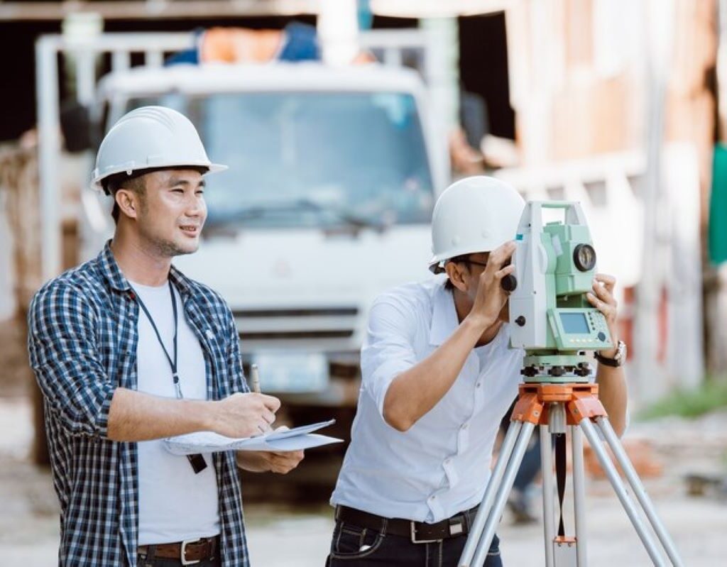
Surveying is a fundamental aspect of construction that involves measuring and mapping land. This process is not merely a preliminary step; it is integral to every stage of the construction lifecycle. Surveying companies conduct vital assessments that inform design decisions and influence the overall feasibility of a project.

The Importance of Accurate Surveying in Construction

Accurate surveying is indispensable to construction planning. It sets the groundwork, literally and figuratively, for any project. When surveying is performed accurately, it provides a reliable framework that architects and engineers can use to design structures. In contrast, inaccuracies in surveying can lead to significant delays, budget overruns, and legal disputes.

Moreover, precise surveying aids in defining property boundaries and land contours, which is essential for adhering to zoning regulations and ensuring that projects remain compliant with local laws. The financial ramifications of inaccurate surveying can be substantial, affecting everything from resource allocation to project timelines. Additionally, the implications of poor surveying can extend beyond financial losses; they can compromise safety, leading to structural failures or accidents on-site, which can endanger workers and the public alike.

Different Types of Surveying Used in Construction Planning

There are several types of surveying that play critical roles in construction planning, each with unique methodologies and purposes:

  • Topographic Surveying: This method maps the features of the land, including elevations, slopes, and natural and man-made structures, to inform site development.
  • Boundary Surveying: Essential for determining the precise lines of ownership and property limits, ensuring compliance with legal standards.
  • Construction Stakeout: Used to lay out the proposed construction based on the design, identifying exact locations for foundations and critical points.
  • As-Built Surveying: Conducted post-construction, this survey records the structure as built to verify compliance with the initial plans and report deviations if they exist.

In addition to these methods, modern surveying increasingly incorporates advanced technologies such as Geographic Information Systems (GIS) and drones. GIS allows for the integration of various data sets, enabling a more comprehensive analysis of the land and its features. Drones, on the other hand, can quickly capture aerial imagery and topographical data, significantly speeding up the surveying process while enhancing accuracy. The adoption of these technologies not only improves efficiency but also provides a wealth of information that can be invaluable in the planning and execution of construction projects.

Furthermore, the role of surveying extends into the realm of environmental considerations. Environmental surveys assess the impact of construction on local ecosystems, ensuring that projects are designed with sustainability in mind. This aspect of surveying is becoming increasingly important as regulations tighten and public awareness of environmental issues grows. By integrating environmental assessments into the surveying process, construction projects can mitigate negative impacts and promote responsible development practices.

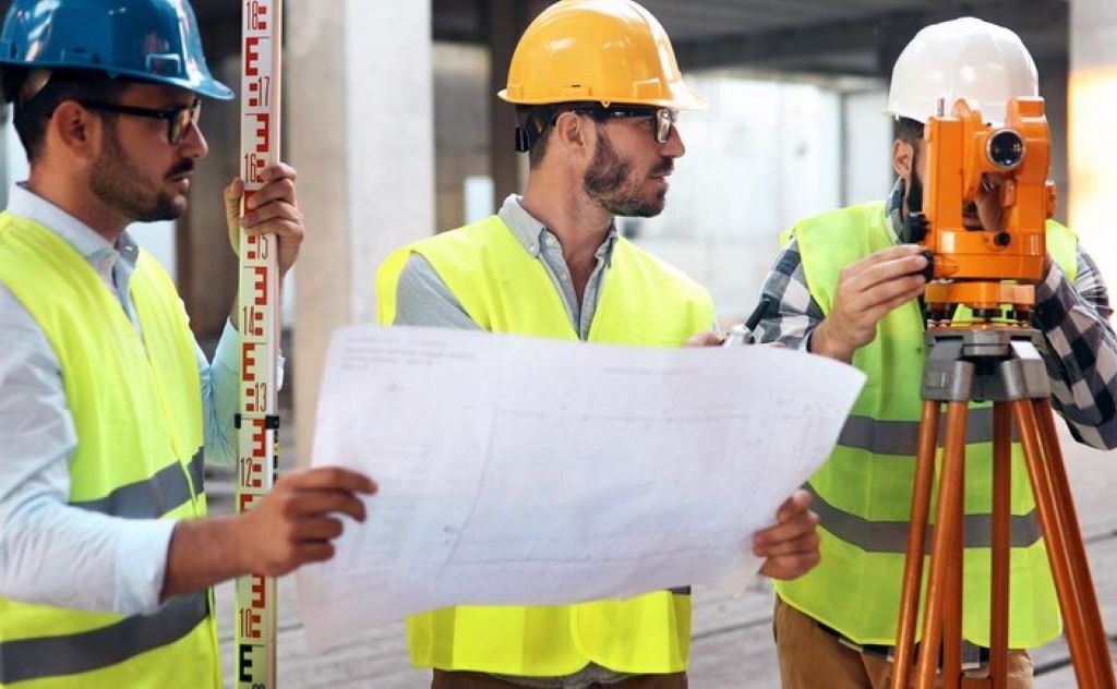
The Process of Construction Surveying

The surveying process is systematic and involves several key stages that ensure thorough assessment and planning. From initial evaluations to detailed surveys, each step is crucial for a successful construction project.

Initial Site Assessment and Land Surveying

The first step in construction surveying is an initial assessment, which typically involves a land survey to gather preliminary data about the site. This survey looks at topographical features, existing structures, and site boundaries.

This information is essential for determining the site’s suitability for the proposed construction. Understanding the landscape helps in identifying any challenges, such as uneven terrain or environmental considerations, which must be factored into the design and execution of the project. Additionally, the initial assessment may also involve a review of local zoning laws and regulations, which can significantly influence the type of construction permitted on the site. By understanding these legal frameworks early in the process, surveyors can provide invaluable insights that help streamline planning and prevent potential legal issues down the line.

Detailed Surveying for Construction Planning

Once the initial assessment is complete, detailed surveying can commence. This phase may involve various advanced tools and technology to create highly accurate models of the intended construction site.

Surveyors often utilise GPS technology, laser scanning, and drones to gather data more efficiently and accurately. This comprehensive surveying enables engineers and architects to develop designs that reflect the realities of the site, drastically reducing the risk of errors during the construction phase. Furthermore, the data collected can be integrated into Building Information Modelling (BIM) systems, allowing for a collaborative approach among all stakeholders involved in the project. This integration not only enhances communication but also facilitates real-time updates and modifications, ensuring that all parties are aligned throughout the construction process. The use of such technology marks a significant advancement in the field of construction surveying, paving the way for more innovative and sustainable building practices.

surveying companies

How Surveying Companies Contribute to Construction Safety

Safety is paramount in construction, and surveying companies play a vital role in ensuring that safety measures are integrated into project plans. Their expertise allows for the identification of hazards early in the planning process.

Identifying Potential Hazards Through Surveying

Through meticulous surveying, companies can pinpoint potential hazards that might pose risks to workers or the structure itself. For instance, surveying can reveal subsurface concerns like unstable soil or water table issues that could undermine structural integrity.

By identifying these hazards upfront, appropriate measures can be put in place, such as design modifications or additional safety protocols, to prevent accidents and ensure the well-being of construction personnel. Furthermore, the use of advanced technologies such as 3D laser scanning and drone surveying has revolutionised the way hazards are detected. These technologies provide a comprehensive view of the site, allowing for a more thorough analysis of the terrain and its potential risks. This proactive approach not only enhances safety but also optimises the construction process, as potential issues can be addressed before they escalate into costly delays.

Ensuring Regulatory Compliance with Accurate Surveying

Surveying companies also help ensure that construction projects comply with local, regional, and national safety regulations. Their expertise in navigating these regulatory landscapes is essential for avoiding legal complications.

Accurate surveying provides the necessary documentation to demonstrate compliance with building codes, zoning laws, and safety requirements, thus safeguarding the project from potential legal pitfalls that could arise from non-compliance. Additionally, surveying professionals often liaise with regulatory bodies, facilitating communication and ensuring that all necessary permits are obtained in a timely manner. This collaboration not only streamlines the approval process but also fosters a culture of safety and accountability within the construction industry. By prioritising compliance, surveying companies contribute to a safer working environment, ultimately benefiting not just the construction teams but also the communities in which these projects are developed.

The Impact of Surveying on Construction Costs

The financial implications of surveying are significant, with well-executed surveys often leading to cost savings throughout the construction lifecycle. Understanding how surveying can influence budgets is essential for any construction project manager.

How Surveying Can Prevent Costly Construction Errors

One of the most substantial benefits of accurate surveying is its ability to prevent costly errors. When the data collected from surveys is precise, it significantly reduces the risk of rework caused by mistakes in the design or execution phases.

Errors that stem from inaccurate measurements can lead to extensive delays and increase material and labour costs significantly. Therefore, investing in quality surveying can translate to considerable savings, negating potential financial losses associated with errors.

Moreover, the use of advanced technology in surveying, such as 3D laser scanning and drone surveys, has revolutionised the accuracy of data collection. These innovations not only enhance precision but also expedite the surveying process, allowing for quicker decision-making and project progression. By utilising these modern techniques, construction teams can identify potential issues early in the project timeline, further minimising the risk of costly errors and ensuring that the project remains on schedule and within budget.

The Role of Surveying in Budgeting and Cost Estimation

Surveying also plays a crucial role in the budgeting and cost estimation phases of a project. By providing accurate and detailed information about the site and design aspects, surveying allows for more precise estimations of costs.

This foundational data aids project managers in allocating resources effectively, setting realistic budgets, and ensuring that funds are used efficiently. Without accurate surveying data, budgeting becomes a guessing game, leading to potential financial shortfalls as projects progress.

Furthermore, the integration of Geographic Information Systems (GIS) into surveying practices enables project managers to visualise and analyse spatial data comprehensively. This capability not only enhances the understanding of site conditions but also facilitates better planning and risk assessment. By leveraging GIS technology, construction teams can anticipate challenges related to terrain, environmental factors, and existing infrastructure, leading to more informed financial decisions and ultimately promoting a smoother construction process. You may like to visit https://www.sl.nsw.gov.au/people-places/planning/understanding-building-design-and-construction-phases to understand building design and construction phases.

Technological Advancements in Construction Surveying

Recent advancements in technology have revolutionised the surveying landscape, bringing about increased efficiency and accuracy. It’s essential to explore these innovations shaping the future of surveying in construction.

The Use of Drones in Construction Surveying

Drones have emerged as a game-changer in the surveying industry. Their ability to capture aerial views and high-resolution images allows surveyors to conduct surveys more efficiently than traditional methods.

Using drones reduces the time and manpower required for large-scale surveys, enabling companies to assess larger areas without the need for extensive ground-based measurements. Moreover, the level of detail captured by drones often surpasses that of conventional methods, providing richer data for analysis.

surveying companies

The Impact of Digital Mapping and 3D Modelling in Surveying

Digital mapping and 3D modelling have also transformed how surveying data is analysed and presented. These technologies enable surveyors to create detailed and comprehensive visual representations of the site, which can be incredibly useful for design and planning.

Through 3D modelling, stakeholders can visualise the project in a simulated environment, allowing for better decision-making and the ability to spot potential issues before construction begins. This proactive approach not only enhances the planning process but also contributes to the overall success of construction projects.

In conclusion, surveying companies play an indispensable role in construction planning. From accurate data collection to advanced technological applications, their contributions affect everything from safety to costs, ensuring that projects are completed successfully and efficiently. As technology continues to advance, the role of surveying in construction will undoubtedly evolve, cementing its position as a vital player in the industry.

More to Read : Everything You Need to Know About Construction Surveys

construction surveyor

Everything You Need to Know About Construction Surveys

Understanding the Importance of Construction Surveys

Construction surveys are vital to the successful execution of any building project. They act as a foundational reference that informs every subsequent step in the construction process. Without accurate surveys, projects can face significant risks, leading to complications that could ultimately delay timelines and inflate budgets.

The importance of construction surveys extends beyond simple measurements; they facilitate efficient project planning and execution by providing essential data on land features, boundaries, and existing conditions. An effective survey allows project teams to visualise and understand the site, hence optimising design and construction strategies.

The Role of Construction Surveys in Project Planning

In project planning, construction surveyor provide critical insights that drive decision-making. They assist engineers and architects in determining the most suitable locations for structures, thereby enhancing the overall design process. By understanding the topography and limitations of a site, teams can innovate more efficiently and effectively.

Moreover, precise surveys delineate areas for construction, ultimately preventing conflicts with local regulations or neighbouring properties. Surveys can also help in assessing environmental impacts, which is increasingly relevant in today’s eco-conscious climate. This information is crucial for securing permits and alignments with zoning laws. Additionally, the data gathered during these surveys can be invaluable for future developments, as it creates a comprehensive record of the site’s characteristics that can be referenced for subsequent projects.

Ensuring Safety and Accuracy Through Construction Surveys

Safety is paramount in construction, and accurate surveys contribute significantly to ensuring a secure working environment. By providing clear data regarding the land and its features, surveys prevent accidents related to miscalculations or misconstructions. For example, if ground conditions are not correctly assessed, it could lead to unstable structures with potentially perilous consequences.

Furthermore, construction surveys involve thorough checks that help in maintaining high construction standards and compliance with legal requirements. Accurate data leads to fewer discrepancies during the construction phase – which not only safeguards the project but also ensures that the final outcome meets or exceeds the expected quality. Additionally, the integration of advanced technologies such as GPS and 3D laser scanning in construction surveys has revolutionised the accuracy and efficiency of data collection. These innovations allow for a more detailed analysis of the site, enabling teams to identify potential issues before they arise, thereby further enhancing safety and project reliability.

The Different Types of Construction Surveys

There are various types of construction surveys, each serving a unique purpose in the project lifecycle. Understanding these different surveys is crucial for selecting the most suitable method for a particular project. Below, we will explore the key types of construction surveys commonly employed in the industry.

Topographic Surveys: Mapping the Land

Topographic surveys are compiled to create detailed representations of the terrain and landscape’s physical features. These surveys map out natural elements such as hills, valleys, water bodies, and existing structures. They establish vertical and horizontal positions, providing a comprehensive overview of the site’s contours.

Topographic surveys are indispensable for architects and engineers, who require detailed information about the geography of the site to make informed design decisions. These surveys can be utilised not just in the planning phase but also during construction to monitor changes in the landscape. The data gathered can also be instrumental in assessing environmental impacts, allowing for more sustainable construction practices. By understanding the topography, professionals can devise strategies to minimise erosion, manage stormwater runoff, and preserve natural habitats, thereby aligning construction projects with ecological considerations.

Boundary Surveys: Defining Property Lines

Boundary surveys are carried out to determine the exact location of property lines and corners. They are vital for preventing disputes with neighbouring landowners and are often used in residential projects where clear demarcation is required. The accuracy of boundary surveys can prevent legal issues related to encroachments and ensure compliance with local regulations.

By obtaining precise data on property boundaries, developers can confidently execute their projects without the fear of overstepping their legal boundaries. Additionally, boundary surveys are critical in establishing easements and right-of-ways necessary for utilities and access roads. This aspect is particularly important in urban areas, where space is often limited and the implications of boundary disputes can be significant. Furthermore, boundary surveys can enhance property value by ensuring that all improvements are within the legal limits, thus providing peace of mind to property owners and investors alike.

Construction Staking: Translating Plans into Reality

Construction staking serves as a transitional phase where survey data is mapped out on the ground, translating project plans into physical markers. It involves placing stakes in the earth to indicate the locations of proposed structures and features, thus guiding construction crews during the building phase.

This process not only ensures that structures are placed correctly according to architectural designs but also helps in visualising the overall layout of the project. Construction staking is crucial for maintaining accuracy, which is vital for the integrity of the finished structure. Moreover, it allows for the identification of potential issues before construction begins, such as conflicts with existing utilities or natural features that may not have been apparent during the planning stages. This proactive approach can save time and resources, ultimately leading to a smoother construction process. Additionally, accurate construction staking can facilitate compliance with zoning laws and building codes, ensuring that the project adheres to all necessary regulations and standards.

The Process of Conducting a Construction Survey

Conducting a construction survey requires a systematic approach that encompasses various stages, from initial research to the final report. Each phase is critical to ensuring the accuracy and reliability of the survey data collected. Below we break down the process into manageable components.

Initial Research and Planning

Before any physical surveying can begin, thorough research and planning are essential. This phase involves reviewing existing maps, satellite imagery, and historical data regarding the site. By understanding the characteristics and history of the area, surveyors can identify any potential challenges that may arise during the survey.

During the planning phase, surveyors establish the objectives of the survey and determine the methodologies they will employ. This proactive approach is crucial for ensuring that all necessary data will be collected and that potential risks are proactively mitigated. Additionally, engaging with local authorities and stakeholders can provide valuable insights into any regulatory considerations or community concerns that may impact the survey process.

construction surveyor

Fieldwork: Gathering Data on Site

Fieldwork is where the actual surveying takes place. Surveyors use various tools and techniques to gather data on-site, including total stations, GPS systems, and laser scanning. This step is critical as it involves obtaining measurements regarding the topography and boundaries directly from the field, providing real-time insights.

Surveyors also take into account environmental factors that may affect their measurements, such as weather conditions and topographical challenges. Adapting to these on-the-ground realities contributes to the overall accuracy of the survey results. Furthermore, the surveyors must be vigilant about safety protocols, ensuring that all personnel are equipped with the necessary protective gear and that the site is secure from potential hazards, which is particularly important in urban areas where construction activities are prevalent.

Data Analysis and Report Preparation

Once fieldwork is complete, the collected data is rigorously analysed to produce comprehensive survey reports. This analysis helps in interpreting the measurements collected, ensuring clarity and accuracy in understanding site characteristics. The findings are then compiled into reports that provide essential information for project stakeholders.

These reports are not just data-driven; they include recommendations and insights based on the survey findings. Issuing clear and understandable reports is imperative for aiding decision-making processes during project planning and execution. In addition, the integration of visual aids such as maps, graphs, and 3D models can significantly enhance the comprehensibility of the data presented, making it easier for stakeholders to grasp complex information and facilitating more informed discussions about the project’s direction and potential modifications.

The Tools and Technology Used in Construction Surveys

The landscape of construction surveying has evolved significantly over the years, with advancements in technology dramatically enhancing the precision and efficiency of the surveys. Both traditional and modern tools play essential roles in various surveying contexts.

Traditional Surveying Tools and Their Uses

Despite the rise of digital technologies, traditional surveying tools remain widely used in the industry. Instruments such as the theodolite, tape measures, and level rods offer reliable means for obtaining measurements. These tools have been foundational in shaping the principles of survey methodology.

Traditional tools often serve distinct purposes: theodolites for angles, tapes for distances, and levels for elevation. Their effectiveness stems from simplicity and reliability, making them indispensable for localised survey needs.

The Rise of Digital Surveying Technology

In contrast to traditional methods, digital surveying technologies have surged in popularity, offering unparalleled accuracy and efficiency. Techniques such as 3D laser scanning, drones, and geographic information systems (GIS) have transformed the surveying process. Situations that might require extensive manpower can now often be completed swiftly using digital means.

These technologies not only increase speed and accuracy but also improve data integration, allowing professionals to visualise projects in innovative ways. Such advancements are not merely trends; they signify a fundamental shift in the survey landscape, making projects more efficient and accessible.

Hiring a Professional Surveyor: What to Consider

When it comes to construction surveys, hiring a professional surveyor is indispensable. However, the process of selecting the right surveyor requires careful consideration of several key factors. By making informed choices, project managers can ensure a smooth surveying process that effectively supports their overall goals. Click here to get how surveying companies assist in construction planning.

Qualifications and Experience: Choosing the Right Surveyor

The qualifications and experience of a surveyor should be a top consideration when hiring a professional. Surveyors should have appropriate educational backgrounds, certifications, and licenses required for their profession. Additionally, experience with specific types of surveys relevant to the project is crucial; for example, a surveyor well-versed in boundary surveys would be less suited for topographic surveys without relevant experience.

Additionally, evaluating previous work and seeking recommendations can provide insight into the surveyor’s expertise and reliability. A proven track record is often an indicator of quality service, ensuring that your project is in capable hands.

construction surveyor

The Cost of Hiring a Professional Surveyor

The cost associated with hiring a professional surveyor is a significant factor that warrants consideration. Surveying fees can vary widely based on project complexity, location, and the surveyor’s level of expertise. It is advisable to obtain quotes from multiple surveyors to gauge a reasonable price range while considering the value of experience and quality of service.

Ultimately, while cost is important, it should not be the sole deciding factor. Investing in a qualified, experienced surveyor can save money in the long run by preventing costly errors and project delays. This prioritisation of quality over cost can yield far better results in the end.